|
Old Wire Road Day Trip
For the most part, evidence of the Old Wire Road in northeast Webster County,
Missouri has been lost to the ages. But in one long stretch, the old worn
path is still visible from the sky. These shots, courtesy of Terraserver,
along with maps, courtesy of Mapquest, follow this path thru Caddo north.
From Strafford to Caddo - Leaving Strafford north on Highway
125, the first road to the right after the stop light is Highway DD. Highway
DD will follow and criss cross the old trail, as it navigates out of Greene
County and into Webster County. At the Webster County line, State Highway
DD ends and Webster County J Road begins. One area where the old trail is
visible in this area is directly after J road declines a long hill and then
takes a sharp 45 degree curve to the left on an incline. At this point J
Road is running alongside a hill, and just below this section of road, the
old trail is still visible in the woods today.
Immediately after this short straight section, the road winds to the right,
crosses another creek and then begins to climb a long hill. Halfway up the
hill the southern section of Beacon Hill Loop meets J Road on the left. This
road will wind out into the countryside and meet back up with J Road a few
miles ahead. Just west of where J Road and Beacon Hill Loop meet here, and
up on the rise that is visible, is where the town of St Mark is believed
to have been.
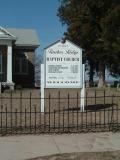
At the top of the hill the road will dip into a low area to the right, and
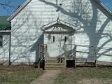
then turn sharply to the left at the Mt Pisgah Baptist Church. In the cemetery
directly to the north of this church rest some of Webster County's oldest
graves.
Down the hill and crossing the Pomme de Terre River, the road will climb
a hill at the top of which, the Beacon Hill Loop intersects J Road once again.
I have been told by residents who grew up in Caddo in the early 90's, that
at one time and in the area of this intersection there was a beacon tower.
This undoubtedly would explain the name of the side road. As the top of this
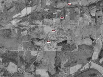
hill is crossed the map below picks up our trail. |
 |
 |
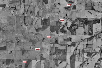
In the photo and matching map above, J Road declines a hill and then will
take a 45 degree angle to the right turning into State Highway J (the
Mapquest map showing DD is incorrect). At this curve, you are in downtown
Caddo, or we should say it once was. Directly to the west of this intersection
and in an empty field, stood the Bodenhamer School. Immediately after the
curve, the first small house on the right still has a large barn and "stable"
that existed in the early 1900's. Across the road from this barn, sits a
home and a business named Balemaster Mfg. Where this house now sits, the
Caddo store once resided. To the right of this business, Daisy Road, a small
dead end dirt road, runs north. At this intersection, the wire road crossed
J and ran where Daisy Road now is, then shot off to the northeast. In the
aerial photo above, the red arrow's mark where the old trail is still evident.
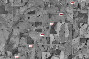
In the next series we see the trail continuing, with very little of the next
few miles following current roads. After driving past Daisy Road, the next
dirt road you will come to is named, fittingly enough, Old Wire Road. Turning
left and heading north on this road, you will go down a hill, cross a creek,
then start climbing again. Near the top of this road is where the old wire
road actually crosses todays present Old Wire Road. It will follow the trail
past the
Walnut
Springs Farm, which has the oldest farm silo in Webster County, to State
Highway E. Here it becomes difficult to follow the trail in an automobile.
For the most part, runs will run north/south or east/west, while the wire
road will head northeast for the remainder of the county. |
 |
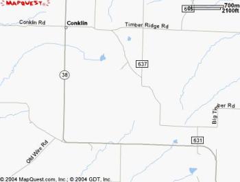 |
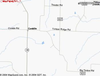
The trail continues northeast, and just north of this area, the aerial evidence
of the trail is lost to vegetation and modern roads. At Old Wire Road and
Highway E, make a right and then turn left onto State Highway 38. Follow
38 north to the once town of Conklin and turn right on Timber Ridge Road.
Continuing on you will come to the Timber Ridge Baptist Church (est
1842) and cemetery.
(Somewhere just south of here is where I believe the old Civil War Sand Springs
Fort was - when I have found it I will update this section)
If you backtrack a few hundred feet, Pleasant Church Road heads to the north.
Take this north, the wire road running to your right. At Theatre Road turn
right, where you will pass the
Frontier
Theatre. |
 |
 |
| It will be difficult to follow the Wire Road for while. Continue
on Theatre Road until it ends at County Road 637. Turn left, then right on
County Road 630. Take this east until it comes to 635 and turn left. Follow
635 until it T's. Take a right on 645B which after crossing a creek and climbing
a small hill, will turn into paved County Highway Y. Y will start coming
close to the Wire road again as it passes Greer Creek Road and will cross
it as you near State Highway W. Turn left on W and then right on Highway
Y again. Here, until you leave Webster County, Highway Y will criss cross
and follow the old wire road.
After crossing thru a few miles of Dallas County, Y ends at M Highway in
Laclede County. Take a right and within a few miles you will be at Interstate
44. |
More as it becomes available
Caddo Home |
|